|
|
Post by Admin on Aug 18, 2023 17:55:23 GMT
The hurricane is expected to make landfall in Baja California. Parts of Southern California could see a year's worth of rainfall in just 24 hours.
Hurricane Hilary intensifying in the Pacific | ABCNL
|
|
|
|
Post by Admin on Aug 18, 2023 18:38:26 GMT
Watch a live tracker of Hurricane Hilary as it approaches Southern California.
Live: Hurricane Hilary storm tracker | NBC News
NBC News
|
|
|
|
Post by Admin on Aug 19, 2023 4:54:55 GMT
Residents of the Southwestern United States are bracing for potential flooding with Hurricane Hilary set to make landfall over the weekend. Hilary reached Category 4 status on Friday, but meteorologists expect it to weaken to a tropical storm by the time it makes landfall and passes over the Baja California peninsula of Mexico. But even a tropical storm would be historic, as one has not struck California since 1939. “Heavy rainfall in association with Hilary is expected to impact the Southwestern United States through next Wednesday, peaking on Sunday and Monday,” reported the U.S. National Hurricane Center. There are also concerns about damage from high winds in the affected areas. On Friday, a tropical storm watch was issued for parts of Southern California — the first ever for that region. Related: What you should do in a flooding emergency, according to experts >> California's Office of Emergency Services announced Thursday it was “already actively coordinating an early, unified and orderly response." California was already pummeled by rain earlier this year caused by numerous atmospheric rivers. 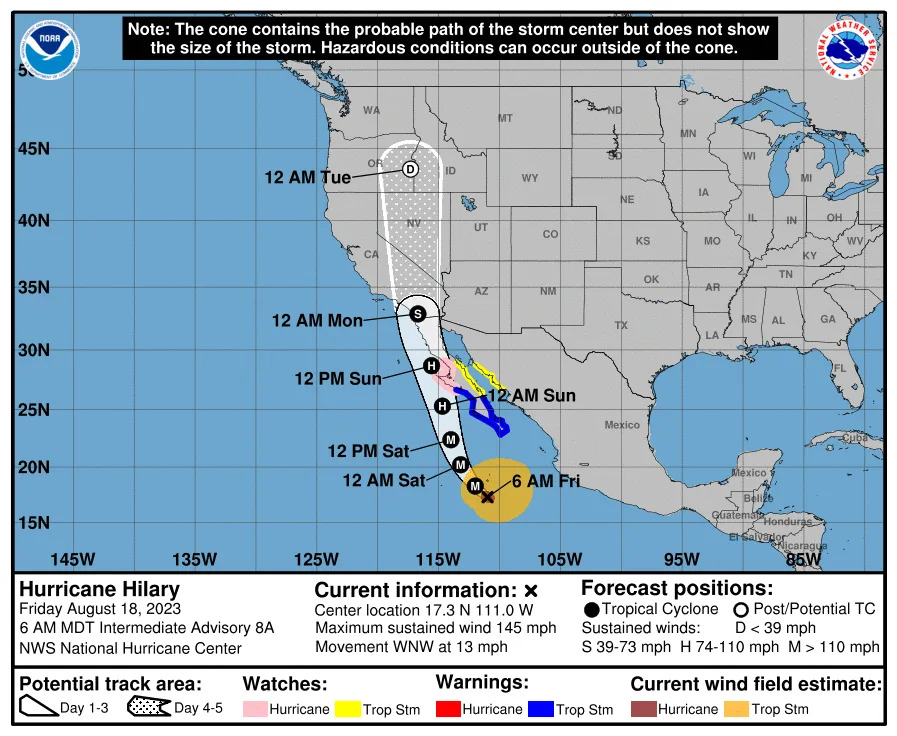 In Southern California, residents of San Diego and Riverside counties have been warned to prepare for up to 10 inches of rain. The city of San Diego averages 0.01 inches of rain in August, and forecasters say the coming deluge could break the August record of 2.13 inches, which was set in 1851. The only recorded instance of the city being hit directly by a hurricane came in 1858. The National Weather Service has a flash flood warning in effect for the region from Saturday morning through Monday. Surfers are also monitoring the conditions, with lifeguards along the Pacific coast preparing to clear beaches if lightning hits in the area. Heavier rain is expected to reach the Los Angeles area on Sunday. On Thursday, the NWS warned residents of the Palm Springs/Coachella Valley area to prepare for potentially more rain than the region would receive in a normal year. Meteorologist Miguel Miller warned residents to stay at home Sunday and Monday due to the potential of flash floods, saying, “We don’t expect the 5 to 6 inches in the valley to fall nice and evenly over three days.” Las Vegas residents are prepping for flooding and flight delays over the weekend, with the usual August rainfall of 0.32 inches potentially tripled by the effects of Hilary. This comes after the hottest July on record for the city. The hurricane center warned that southern Nevada is among the areas at particular risk, along with western portions of Arizona, which have flood watches in effect. The potential damage comes with the Federal Emergency Management Fund disaster fund nearly depleted after the wave of billion-dollar climate disasters already this year. FEMA has urged Congress to pass a new spending bill to make up for the difference. |
|
|
|
Post by Admin on Aug 19, 2023 19:58:49 GMT
Hurricane Hilary has prompted the first-ever Tropical Storm Watch for Southern California. The first-of-its-kind Watch was issued for a wide swath of the region including Catalina Island and northern Los Angeles County.
The storm’s impacts will vary widely across the County.
The National Weather Service issued this detailed localized forecast for Pasadena at 3:55 a.m. Saturday morning:
Today: A 20 percent chance of showers and thunderstorms after noon. Partly sunny, with a high near 87. South wind 5 to 10 mph, with gusts as high as 15 mph.
Tonight: A 40 percent chance of showers and thunderstorms. Cloudy, with a low around 69. South wind 5 to 10 mph becoming northeast after midnight. New rainfall amounts of less than a tenth of an inch, except higher amounts possible in thunderstorms.
Sunday: Showers and possibly a thunderstorm. High near 83. Breezy, with an east northeast wind 10 to 15 mph becoming north 15 to 20 mph in the afternoon. Winds could gust as high as 30 mph. The chance of precipitation is 90%. New rainfall amounts between three quarters and one inch possible.
Sunday Night: Showers and possibly a thunderstorm. Some of the storms could produce heavy rainfall. Low around 65. Breezy, with a north wind 15 to 20 mph becoming south southeast after midnight. Winds could gust as high as 30 mph. The chance of precipitation is 100%. New rainfall amounts between 1 and 2 inches possible.
Monday: Showers and thunderstorms before noon. Some of the storms could produce heavy rain. Patchy fog after noon. High near 79. Southeast wind around 10 mph becoming southwest in the afternoon. Winds could gust as high as 15 mph. The chance of precipitation is 80%. New precipitation amounts between a tenth and quarter of an inch, except higher amounts possible in thunderstorms.
Monday Night: Patchy fog after midnight. Otherwise, cloudy, with a low around 60.
Tuesday: Patchy fog before noon. Otherwise, partly sunny, with a high near 80.
Tuesday Night: Mostly clear, with a low around 61.
Wednesday: Sunny, with a high near 85.
Wednesday Night: Mostly clear, with a low around 63.
Thursday: Sunny, with a high near 86.
Thursday Night: Mostly clear, with a low around 63.
Friday: Sunny, with a high near 87.
|
|
|
|
Post by Admin on Aug 20, 2023 5:04:29 GMT
Gov. Newsom declares a state of emergency ahead of Hurricane Hilary’s expected landing in Southern California. Rob Mayeda, Alyssa Goard and Marianne Favro report.
|
|

