|
|
Post by Admin on Mar 20, 2014 23:47:56 GMT
Satellite images off the coast of Australia may show objects related to MH370. How are officials pursuing this new lead? Search crews battled rainy and foggy conditions Thursday night as they zeroed in on the best lead so far about 1,500 miles off the west coast of Australia in the case of a Malaysia Airlines plane missing for nearly two weeks. By about 8 p.m. in Perth, Australia, a Norwegian ship had reached the site of two pieces of floating debris, one measuring about 79 feet, and second being about 16 feet in length.  Satellite images captured images of the suspected debris of Flight MH370, giving the nations scouring some 2.2 million square miles of the Indian Ocean and surrounding countries a speckle of hope that they may have found the plane that's been missing since March 8. Authorities said the plane had enough fuel for about seven hours of flight. “This is a lead, it’s probably the best lead we have right now,” John Young, manager of the Australian Maritime Safety Authority’s emergency response division said at an early afternoon press conference from Canberra.  The possible find could bring some measure of closure to family members of the 227 passengers and 12 crew aboard the doomed night flight, which left Kuala Lumpur, Malaysia, for a six hour flight to Beijing, China. Air traffic controllers lost contact with the Boeing 777 aircraft about 40 minutes into the flight, and later revelations showed the plane had been most likely deliberately steered off course, sparking fears of a hijacking and opening new lanes for what has been a long and desperate search. |
|
|
|
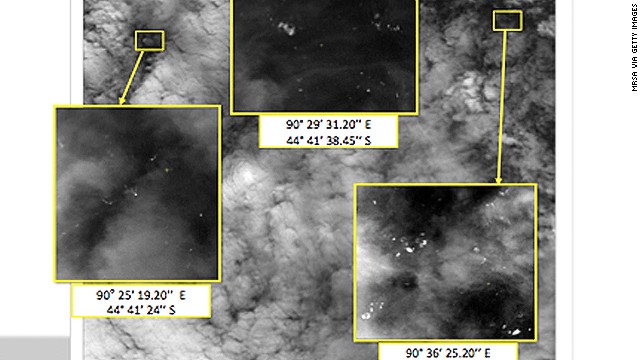
Post by Admin on Mar 23, 2014 6:31:08 GMT
A satellite image released by China on Saturday offered the latest sign that wreckage from a Malaysia Airlines plane lost for more than two weeks could be in a remote stretch of the southern Indian Ocean where planes and ships have been searching for three days. The image, showing an object 72 feet by 43 feet, was taken around noon Tuesday. The image location was about 75 miles south of where an Australian satellite viewed two objects two days earlier. The larger object was about as long as the one the Chinese satellite detected. "The news that I just received is that the Chinese ambassador received a satellite image of a floating object in the southern corridor and they will be sending ships to verify," Malaysian Defense Minister Hishammuddin Hussein told reporters Saturday.  Australian officials said the location was within the 14,000-square-mile area they searched on Saturday, but the object was not found. Australian Maritime Safety Authority spokeswoman Andrea Hayward-Maher said she did not know whether the precise coordinates of the location had been searched, but added that coordinators will use the information to refine the search area. The Australian Maritime Safety Authority, which is overseeing the search in the region, said a civil aircraft reported seeing a number of small objects in the search area, including a wooden pallet, but a New Zealand military plane diverted to the location found only clumps of seaweed. The agency said in a statement that searchers would keep trying to determine whether the objects are related to the lost plane. |
|
|
|
Post by Admin on Mar 27, 2014 5:50:44 GMT
 New satellite images provided by a French defense firm show 122 objects floating in the southern Indian Ocean, not far from other satellite sightings that could be related to missing Malaysia Airlines Flight 370, the Malaysian transport minister said Wednesday. When photographed by the satellite on Sunday, the objects were scattered over 154 square miles (400 square kilometers), acting Transportation Minister Hishammuddin Bin Hussein said. That's about the size of Denver, Colorado.  The location recorded by the satellite was within the search area scoured Wednesday by a dozen aircraft from six nations, the Australian Maritime Safety Authority said. Nothing was found, the agency said on Twitter. Experts say it's possible the materials may have drifted or sunk. Search aircraft did spot three objects, but teams weren't able to locate them again in several passes through the area, the Australian Maritime Safety Authority said. The latest objects seen on satellite images provided by Airbus Defence and Space range from about 3 feet (1 meter) to about 75 feet (23 meters), Hishammuddin said. Some appear bright, indicating they may be solid, he said. The latest images appear to be the most significant discovery yet in the hunt for the missing plane, which vanished March 8 with 239 people aboard, said CNN aviation analyst Miles O'Brien. "There's a very good chance this could be the break we've been waiting for," he said. Aviation safety analyst David Soucie agreed, saying he was particularly intrigued by the size of the 75-foot object. "It has potential to be a wing that's floating," he said. "So I'm really encouraged by it, I really am." |
|
|
|
Post by Admin on Mar 29, 2014 5:49:02 GMT
 Five aircraft searching in a new location for missing Malaysia Airlines flight MH370 spotted multiple objects at sea on Friday, according to the Australian Maritime Safety Authority (AMSA). A Thai satellite has detected 300 floating objects in the southern Indian Ocean where an international search is under way for a missing Malaysian jet liner, Thailand’s Geo Informatics and Space Technology Development Agency (GISDA) said.The objects were spotted around 2,700km south-west of Perth by the satellite “Thaichote” on March 24, the GISDA said in a statement. Eight planes were ready to comb the newly targeted area off the west coast of Australia after several objects were spotted Friday, including two rectangular items that were blue and gray, and ships on the scene will attempt to recover them, the Australian Maritime Safety Authority said. "The objects cannot be verified or discounted as being from MH370 until they are relocated and recovered by ships," the authority said in a statement. "It is not known how much flotsam, such as from fishing activities, is ordinarily there. At least one distinctive fishing object has been identified."  The radar data that was re-analyzed was received soon after Flight 370 lost communications and veered from its scheduled path March 8. The Beijing-bound flight carrying 239 people turned around soon after taking off from Kuala Lumpur, flew west toward the Strait of Malacca and disappeared from radar.The search area has changed several times since the plane vanished as experts analyzed a frustratingly small amount of data from the aircraft, including the radar signals and "pings" that a satellite picked up for several hours after radar and voice contact was lost. |
|
|
|
Post by Admin on Apr 2, 2014 22:38:54 GMT
A police investigation may never determine the reason why the Malaysia Airlines jetliner disappeared, and search planes scouring the Indian Ocean for any sign of its wreckage aren’t certain to find anything either, officials said Wednesday. The assessment by Malaysian and Australian officials underscored the lack of knowledge authorities have about what happened on Flight 370. It also points to a scenario that becomes more likely with every passing day — that the fate of the Boeing 777 and the 239 people on board might remain a mystery forever.  The plane disappeared March 8 on a flight to Beijing from Kuala Lumpur after its transponders, which make the plane visible to commercial radar, were shut off. Military radar picked up the jet just under an hour later, on the other side of the Malay peninsula. Authorities say until then its “movements were consistent with deliberate action by someone on the plane” but have not ruled out anything, including mechanical error. Police are investigating the pilots and crew for any evidence suggesting they may have hijacked or sabotaged the plane. The backgrounds of the passengers, two-thirds of whom were Chinese, have been checked by local and international investigators and nothing suspicious has been found. “Investigations may go on and on and on. We have to clear every little thing,” Inspector General Khalid Abu Bakar told reporters in Kuala Lumpur. “At the end of the investigations, we may not even know the real cause. We may not even know the reason for this incident.”  The Australian Navy ship the HMAS Success is seen during the continuing search in the southern Indian Ocean for the missing Malaysian Airlines flight MH370 in this picture released by the Australian Defence Force today. With no other data available indicating where the plane went down, spotting wreckage is key to narrowing down the search area and ultimately finding the plane’s flight data recorders, which will provide a wealth of information about the condition the plane was flying under and possibly the communications or sounds in the cockpit. The data recorders emit a “ping” that can be detected by special equipment towed by a ship in the immediate vicinity. But the battery-powered recorders stop transmitting the “pings” about 30 days after a crash. Locating the data recorders and wreckage after that is possible, but it becomes an even more daunting task. |
|

