|
|
Post by Admin on May 25, 2018 18:24:17 GMT
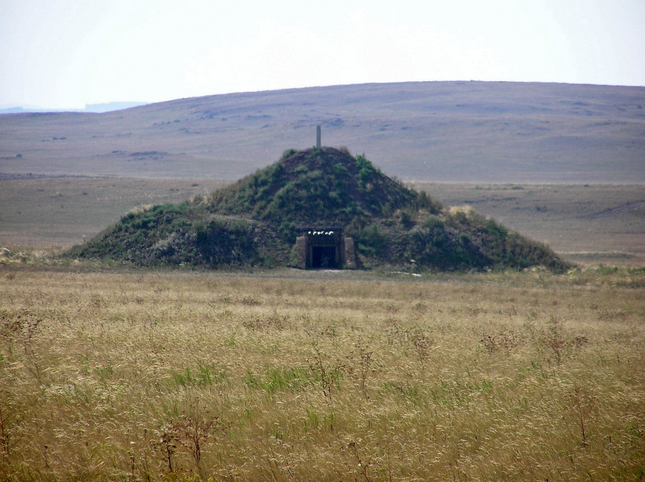
 Figure 8.4: Mar'inskaya 5. Grave 25 with bucrania. (1) Marinskaya 3, Russia N 43.925°, E 43.530° Excavation Lomonosov Moscow State University, Institute of Archaeology RAS, ‘Nasledie’ 2007, licence № 2007-687 (A.R. Kantorovich), 840 (V. Ye. Maslov) In 2007 a huge burial mound near the village of Marinskaya was excavated by the Lomonosov Moscow State University, the Institute of Archaeology RAS and the local heritage organisation ‘Nasledie’33. The excavated mound 1 was part of a cemetery of then three visible and several ploughed-over burial mounds on the high terrace of the river Kura. The site is situated in a herb-grass steppe environment1, which was formerly intersected by forests. The barrow was more than 4 m high and about 40 m in diameter and surrounded by a circular ditch about 2.5 m deep, which was visible on aerial and satellite images and later partly excavated. The excavation of the mound revealed two main phases of construction: the first mound-shell dates to the Maykop period. Beneath this shell is a deep rectangular burial pit with an undisturbed late Maykop burial (grave 18) placed on a floor paved with river pebbles33. The pit was dug into the ground and had a wooden ceiling, which was covered and surrounded by a rectangular stone construction. The walls of the pit were plastered and painted in red and bright yellow. Grave 18 is dendrochronologically dated. The first mound-shell was built on-top of this grave and the empty stone construction of grave 2 possibly also belongs to this phase. The second mound-shell dates to the Middle Bronze Age and was constructed in several layers, during which 14 graves were interred. Six graves are associated with the North Caucasus cultural formation (grave no. 3, 6, 12, 13, 16, and 17), while eight graves (no. 5, 7-9, 11, 14, 15, and 17) belong to the Catacomb cultural tradition (Suvorovo variant). The stratigraphy suggests that the shallower graves had initially been placed around the Maykop mound and were only later covered by the layers of Middle Bronze Age construction phases. Finally, an Early Iron Age grave and a Sarmatian grave 4/10 were interred in the Bronze Age mound, both of them severely damaged by later grave robbers. One individual produced genome-wide data: •MK3003.A0101.TF1 (BZNK-051/1), kurgan 1, grave 7, poorly preserved inhumation of the Catacomb epoch in a T-shaped catacomb with bronze ornaments and some animal bones. Dating: 2577-2476 calBCE (4020±22BP, MAMS-29809)  12 Weapon and tools from the Marinskaya kurgan Marinskaya 5, Russia N43.905354°, E 43.521883° Excavation Lomonosov Moscow State University, Institute of Archaeology RAS, ‘Nasledie’ 2009, licence № 2009745 (A.R. Kantorovich), 2009-762 (V.Ye. Maslov) The huge, single-standing burial mound Marinskaya 5, situated 2.3 km southwest of the mound group Marinskaya 3 was excavated in 2009 by a team of the Lomonosov Moscow State University, the Institute of Archaeology RAS and the local heritage organization ‘Nasledie’. The kurgan is situated on the high terrace of the river Kura. The mound was slightly oval with a diameter of 34 to 40 m and 4.3 m high. At a distance of 10-16 m a ditch of 1.5 m depth surrounded the mound, which was detected on aerial images and excavated later. In the central part of the mound, the excavations uncovered three mound-shells or construction phases dating to the Early Bronze Age Maykop epoch and one that was constructed during the Middle Bronze Age. The first constructive feature in the mound was the above-ground burial vault of grave 33, surrounded by an oval fencing built from river pebbles. The first shell, an earth and stone construction, was built directly on top of this construction. Two following early Maykop burials 32 and 34 were entrenched in the centre. The second mound-shell was associated with late Maykop burials 12 and 16 and was added later. The third mound-shell was constructed after the interment of late Maykop grave 25. These mound-shells were complex earthen constructions and each were covered by a stone shell. All burials except grave 25 were situated on top of each other in the centre of the mound. Grave 12 is dendrochronologically dated27, all others inhumations are radiocarbon dated. The Maykop stratigraphy has recently been published in Russian34. In several graves, among them late Maykop grave 25 and North Caucasus graves 19, 23, 30/30a, paired cattle skulls were found. They place this site among one of the earliest, where the use of cattle as draught animals is documented in a chronological sequence6. After a hiatus of 600 years 18 graves (no. 3, 10, 13, 15, 17-24, 26-29, 30A, and 31) dating to the North Caucasus cultural formation were added, including another mound shell. Two graves (no. 4 and 14) dated to the Late Bronze Age/post-Catacomb epoch based on burial practice and radiocarbon dates, and two nearly destroyed burials (no. 8 and 11) perhaps also date to the Bronze Age. One catacomb grave, also dating to the local Middle Bronze Age, intersected the ring of the North Caucasus graves and destroyed an earlier interment (no. 30/30A). During the Late Iron Age five additional graves were added in the centre of the mound. which can be attributed to the Sarmatian epoch. Grave 1 can be associated with the Early Iron Age of the late 8th to early 7th century BCE and the others (no. 2, 5, 6, 9) date to the early Sarmatian epoch, i.e. the 3rd to 1st century BCE. •MK5005.C0101.TF1 (BZNK-079/1), kurgan 1, grave 32, an early Maykop secondary interment into the second mound-shell on top of the first burial. The grave was without inventory but is according to the stratigraphy associated with the early Maykop complexes. Dating: leather 3640-3370 calBCE (4720±25BP, UGAMS-13047); human bone 3341-3098 calBCE (4496±26BP, MAMS-11212) •MK5001.A0101.TF1+ B0101.TF1 (BZNK-065/5+3), kurgan 1, grave 12, a partly disturbed Late Maykop inhumation slightly south of the centre with bronze weapons and a ceramic vessel. The grave is dendrochronologically dated with an end date of 3279 BCE + 25 years for missing sapwood27. Dating of the skeleton: 3348-3035 calBCE (4491±32BP, MAMS-110555) •MK5008.B0101.TF1 (BZNK-066/3), kurgan 1, grave 16, a Late Maykop inhumation in the center of the mound with a wooden vessel(?). Dating: 3364-3107 calBCE (4544±25BP, MAMS-29810) •MK5004.A0101.TF1+D0101 (BZNK-073/4+2), kurgan 1, grave 25, which was a disturbed Late Maykop inhumation burial in a square burial chamber. Bronze weapons, a golden earring and a ceramic vessel remained from the inventory. Additionally, two cattle skulls with bronze nose rings and the remains of a possible yoke were found in situ outside the chamber. Dating of wood remains from the grave construction: 3347-3095 calBCE (4498±30BP, MAMS-110554) •MK5009.A0101.TF1 (BZNK-064/2), kurgan 1, grave 10, a North Caucasus grave inside a well preserved wooden massive construction in a deep grave shaft. The inventory included a stone object and animal bones. This complex is likewise dendrochronologically dated with an end date of 2644 BCE + 13 years uncertainty for missing sapwood27. Dating of the skeleton: 2884-2636 calBCE (4175±31BP, MAMS-110548) |
|
|
|
Post by Admin on May 27, 2018 18:20:19 GMT
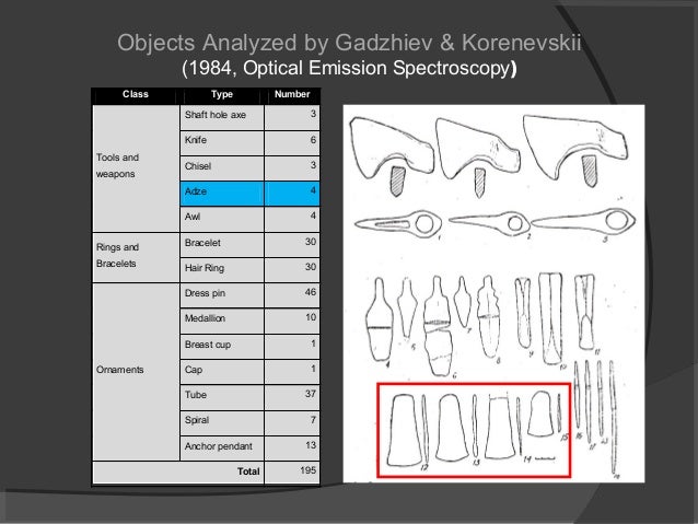 Sharakhalsun 6, Russia N 45.725651°, E 43.21986933° Excavation ‘Nasledie’, Stavropol 2001, licence №2001-791 (A. V. Yakovloev) The sites of Sharakhalsun are located about 70 km south of Elista in one of the densest clusters of burial mound cemeteries in the Caspian steppe. The cemetery is one of several hundred similar formations in this area and like most of them organized in a line running West-East. It is situated on the right bank the river Kalaus not far from its entry into the major river Manych, which is now the Manych water reserve. More than 330 graves were excavated by different ‘Nasledie’ field campaigns in this area and through rescue excavations during the construction of the Manych water reserve, which resulted in a large number of excavated complexes. In addition, detailed seminal studies on the dating but also subsistence and mobility patterns were conducted by Natalya I. Shishlina not far from the Sharakhalsun sites3. The studied mound 6 in the cemetery of Sharakhalsun 2 was uncovered during rescue excavations in 2001. The mound was 50 m in diameter and 3 m high. The stratigraphy is not entirely clear, but the first mound was constructed by communities of the early Steppe Maykop formation in the late 4th millennium BC, of which founding grave 17 produced genome-wide data. Grave 16 was added shortly after. The second mound-shell was also built by early Steppe Maykop groups and graves 12 and 15 date to this period40. The third Maykop cluster dates to the second half of the 4th millennium BC. It includes grave 6, 11 and the atypical grave 18, which are among those that produced genome-wide data. This grave belongs to a specific group, with influences from Maykop and Yamnaya traditions3. During the 3rd millennium, Yamnaya groups used the Maykop mound and added several graves in central positions and on the periphery as well as at least one new mound-shell. The last interments (graves 1, 2, 7,8 and wagon grave 9) belong to the late Bronze Age Catacomb period. Empty grave 10 can only roughly be dated to the Middle Bronze Age. Mound 6 in Sharakhalsun revealed four complexes with remains of wooden wagons belonging to different cultural formations. It is one of few places with a concentration of wagon burials among the hundreds of excavated mounds in the vicinity and yielded the oldest dated wooden wagon so far in grave 186. This individual probably was one of the first that adopted this new technology in the North Caucasian and Caspian steppe41. The complexes of Sharakhalsun are part of a larger bioarchaeological study and are scheduled for full publication in 2019. Five individuals produced genome-wide data: •SA6003.B0101 (BZNK-010/2), kurgan 2, grave 9, a late Catacomb grave of an individual squeezed into a small and narrow catacomb and covered with the half of a four-wheeled wagon. Grave good include a wooden vessel, a ceramic incense burner and a bronze pricker. Dating: 2474-2211 calBCE (3890±40BP, GIN-12400) •SA6013.A0101 (BZNK-009/2), kurgan 2, grave 11, affiliated with the Steppe Maykop had a ceramic vessel as grave good. Dating: 3355-3105 calBCE (4524±22BP, MAMS-29246) •SA6010.A0101 (BZNK-008/3), kurgan 2, grave 13, typical Yamnaya burial position with a flint artefact. Dating: 2884-2679 calBCE (4185±23BP, MAMS29821) •SA6001.A0101 (BZNK-004/3), kurgan 2, grave 17, Maykop founding grave in the mound, child burial in an oval catacomb with entrance pit, including a ceramic vessel. Dating: 3619-3369 calBCE (4673±28BP, MAMS-31143) •SA6004.A0101 (BZNK-003/1+4), kurgan 2, grave 18, Steppe Maykop. This exceptional grave is an inhumation of a male individual sitting on a four-wheeled wooden wagon in a narrow catacomb. No additional grave offerings were found. The physical anthropological examination of this individual revealed a large number of pre- and peri-mortem injuries41. Dating: wood, 3336-3105 calBCE (4500±40BP, GIN-12401) 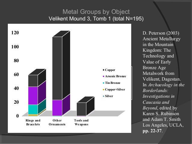 Rasshevatskiy 4, Russia N 45.535978° E 41.059517° Excavation ‘Nasledie’, Stavropol 1999, licence №1999-62 (J. B. Berezin) Only 4 km to the southwest of Rasshevatsky 1 another parallel line of mounds runs west-east - Rasshevatsky 4. Here six mounds were excavated during rescue excavations in 1999. The most eastern was mound 1 with an oval form, a diameter of 18-35 m, and a preserved height of 0.36 m. In the mound three Catacomb burials and two burials in pits were discovered, dating most likely to the post-Catacomb horizon. Three individuals produced genome-wide data: •RK RK4001.A0101 (BZNK-284/1), kurgan 1, grave 4, a poorly preserved inhumation in crouched position without inventory. Dating: 2338-2210 calBCE (3837±22BP (MAMS-29819) •RK4002.B0101 (BZNK-304/2), kurgan 1, grave 5, a Catacomb grave in a T-shaped catacomb with bent up knees. No inventory. Dating: 2618-2497 calBCE (4050±22BP (MAMS-29820) |
|
|
|
Post by Admin on May 29, 2018 18:16:11 GMT
 Progress 2, Russia N 43.822691°, E 43.350278° Excavation ‘Nasledie’, Stavropol 2009-10, licence №209-545 (S. Ja. Berezin) In the same environmental zone as the sites of Marynskaya 3 in the piedmont steppe zone of the North Caucasus, in a distance of 20 km five of the ten mounds of the group Progress 2 were excavated prior to gravel extraction in the former riverbeds of the river Malka. Here, the entire river terraces are dotted with burial mounds of which several have been excavated in the 1970’s. The mounds were located on the first terrace on the left side of the river. Several mounds were clustered, while mounds 5 and 10 were slightly separated. Mounds 1 and 4, from which the sampled individuals stem, were part of one cluster. Most of the burials in all mounds date to the North Caucasus cultural formation, but mound 1 and 4 were firstly built on top of Eneolithic inhumations. Two of them were sampled and produced genome-wide data. Mound 1 was the largest mound with a diameter of 40 m and a height of 2.2 m. Its construction comprised three phases with two stone shells and a stone circle. In the 18-19th century the place was used as a cemetery by the local Islamic population. The founding grave 37, which was sampled for aDNA analysis, dates to the Eneolithic epoch and is related to the aforementioned group of Don-Caspian-Caucasus Eneolithic complexes. Of the remaining burials in this mound two are associated with the Yamnaya epoch, and eleven graves date to the Middle Bronze Age with inventories attributed to the North Caucasus formation. Mound 4 was smaller with a diameter of 20 m and a remaining height of only 0.3 m. The founding graves were two Eneolithic burials, graves 9 and 12, which were found side by side and revealed practically identical radiocarbon dating. Both skeletons were thickly packed in red ochre and grave 12 revealed a complex trepanation35. One grave in this mound is associated with Yamnaya, four with the Middle Bronze Age (North Caucasus) and one burial dates to the Sarmatian period. Three individuals from Progress 2 produced genome-wide data: •PG2001.B0101.TF + B0201.TF (BZNK-113/4), kurgan 1, grave 37, was the Eneolithic founding grave in mound 1 was found in an oval pit, thickly packed in red ochre. The grave goods consisted of a long flint blade, a flint adze, a flint projectile head and another flint object. A radiocarbon doublet of charcoal and human bone revealed a strong reservoir-effect in the human bone date. Dating: human bone 4991-4834 calBCE (6012±28BP, MAMS-110564), charcoal 4336-4173 calBCE (5397±28BP, MAMS-110563) •PG2002.A0101.TF (BZNK-303/1), kurgan 1, grave 25b. The burial was placed in a rectangular pit attributed to the North Caucasus culture and was equipped with bronze ornaments and a collier of bronze and gagat beads. On top of this grave a second North Caucasus grave 25a without grave goods was discovered. Dating: 2483-2342 calBCE (3929±22BP, MAMS-29815) •PG2004.A0101.TF + C0101.TF (BZNK-062/1+3), kurgan 4, grave 9, was one of the two Eneolithic founding graves in the mound. The individual was found in a shallow grave pit packed in a thick layer of red ochre. The grave inventory contained the fragment of a ceramic vessel, a long flint blade and a bone object. Dating: 4233-4047 calBCE (5304±25BP, MAMS-11210)  Rasshevatskiy 1, Russia N 45.537249° E 41.116544° Excavation ‘Nasledie’, Stavropol 1998-2000, licence №2000-252 (V. L. Rostunov) The burial mound cemetery Rasshevatskiy 1 is one of several groups of mounds that run in long lines from West to East. The vegetation today is a herb-steppe with larger patches of forest steppe vegetation1. The actual cemetery included 27 mounds and extended across 2 km, with distances between mounds varying from 30 to 130 m. Mound 21 with an oval to ogival shape was 110 m long, 85 m wide and 6 to 6,4 m high36, 37, 38. It was excavated during rescue excavation in 2000 and is one of the two largest mounds in the group. The mound was built in five construction layers or mound-shells of different forms and earth compositions. Mound-shell 1 was constructed from dark-brown and brown loamy substrate in an egg-shaped form with an axis running North-South. It is associated with the Steppe Maykop formation, the founding burial is grave 14. Mound-shell 2, still egg-shaped, was built over the empty burial pit 3 in the Yamnaya period; graves 9, 11 and 13 were inserted into this shell and are also associated with the Yamnaya epoch. Two of the individuals from this epoch were sampled and produced genome-wide data, grave 11 revealed the oldest evidence of an early form of Yersinia pestis39. The second mound was entirely covered by a thin layer of light grey river-clay. The third mound-shell is associated with Novotitorovskaya groups. Its founding burial was grave 7, which was accompanied by a dismantled wagon. Graves 15, 17, 18 and probably 19 are associated with mound-shell 3. By this time, the mound was transformed into an oval construction with a flat top. Mound-shell 4, a construction of several layers among them dark- and light brown loamy substrates, is associated with North Caucasus grave 16. Grave 21 of the same cultural formation possibly also belongs to shell 4. This was the third individual that produced genome-wide data. After that, the mound was considerably enlarged and had a flat top-platform, but its axis was still running North-South. The construction of mound-shell 5 included a considerable enlargement and a turn of the main axis from North-South to East-West. The founding burial, grave 8, is dated to the early Catacomb period with three wagons standing beside the grave pit (labelled initially ‘grave 6’). Graves 2, 4, 12, the sacrificial pit ‘grave’ 1, and possibly grave 20 are also associated with the late Catacomb phase. Grave 5 on top of the mound dates to the medieval period, and the empty grave(?) pit 22 cannot be securely dated. The complexes of mound 21 from Rasshevatsky are part of a larger bioarchaeological study and are scheduled for full publication in 2018/19. Three individuals produced genome-wide data: •RK1001.C0101 (BZNK-034/4), kurgan 21, grave 11, a typical Yamnaya burial with an individual in crouched position on the back, legs bent upwards. No inventory was associated with this grave. Dating: 2879-2673 calBCE (4171±22BP, MAMS-29816), when modeled according to stratigraphy the date changes to 2880-2798 calBCE •RK1007.A0101 (BZNK-035/2), kurgan 21, grave 13, which is a typical Yamnaya burial in a crouched position on the back. The deceased was accompanied by a ceramic vessel. Dating: 3308-3026 calBCE (4447±22BP, MAMS-29818; when modeled according to stratigraphy the date changes to 3262-3025 calBCE) •RK1003.C0101 (BZNK-042/3), kurgan 21, grave 21, a North Caucasus interment in a deep, rectangular burial pit, covered by wooden planks. Grave goods comprised a bone pin and a silver earring. Dating: 2802-2761 calBCE (4218±24BP, MAMS-29817), when modeled according to stratigraphy. Rasshevatskiy 4, Russia N 45.535978° E 41.059517° Excavation ‘Nasledie’, Stavropol 1999, licence №1999-62 (J. B. Berezin) Only 4 km to the southwest of Rasshevatsky 1 another parallel line of mounds runs west-east - Rasshevatsky 4. Here six mounds were excavated during rescue excavations in 1999. The most eastern was mound 1 with an oval form, a diameter of 18-35 m, and a preserved height of 0.36 m. In the mound three Catacomb burials and two burials in pits were discovered, dating most likely to the post-Catacomb horizon. Three individuals produced genome-wide data: •RK RK4001.A0101 (BZNK-284/1), kurgan 1, grave 4, a poorly preserved inhumation in crouched position without inventory. Dating: 2338-2210 calBCE (3837±22BP (MAMS-29819) •RK4002.B0101 (BZNK-304/2), kurgan 1, grave 5, a Catacomb grave in a T-shaped catacomb with bent up knees. No inventory. Dating: 2618-2497 calBCE (4050±22BP (MAMS-29820) |
|
|
|
Post by Admin on May 31, 2018 18:23:44 GMT
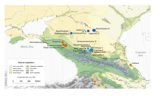 The Maykop ‘culture’ or cultural formation is the first Early Bronze Age culture in the Caucasus. This enigmatic phenomenon exhibits the first gigantic burial mounds with splendid ‘royal’ tombs4, 5 containing exquisite burial gifts in gold, silver and bronze that unfold an entire spectrum of technical innovations in metallurgy (but not restricted to). Maykop plays a key role in the transfer of technical innovations and social alterations to the West. An increase in sites, the expansion of territories, the enlargement of burial mounds as well as large groupings of mounds in cemeteries indicate a prospering culture and population growth. The economy seems to have been based on an agro-pastoral to pastoral subsistence with a focus on cattle herding, but detailed economic data are largely missing. Judging by the artefact spectrum, the early phase of this phenomenon appears closely linked to northern Mesopotamia17. A specific component of the Maykop phenomenon is found in sites located in the modern steppe zone. We refer to them here as Steppe Maykop (cf. 3). These burials share elements of mortuary practices and artefacts with piedmont Maykop groups but at the same time reveal Eneolithic and autonomous components from the steppe. Both Maykop-related phenomena develop in parallel. 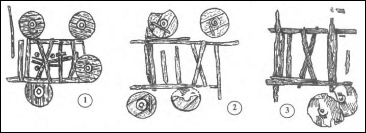 The Maykop individuals in the present study stem from a variety of sites related to both Steppe and piedmont and date to an earlier (3900-3500 calBCE) and later chronological phase (3500-2900 calBCE), respectively. A more detailed chronology can be found in the cited literature. Some sites in the steppe-zone might be affected by a radiocarbon reservoir effect18, but even a correction of 100-150 would still render them contemporaneous to the groups in the piedmont zone. The earlier individuals are labelled ‘Maykop’, ‘Steppe Maykop’ and stem from sites like Nogir, Klady and Marinskaya 5 in the piedmont and foothill zone, as well as individuals from Aygursky 2 and Sharakhalsun 2 in the steppe zone. The later Maykop phase, labelled ‘Late Maykop’ or ‘Maykop-Novosvobodnaya’, is represented by western sites such as Klady or Sinyukha, Baksanyonok and Marinskaya 5 in the central piedmonts, and Ipatovo in the steppe zone. Technical innovations culminate during the advanced stage of Maykop including evidence of wheeled transport and related technologies6, high-quality textiles including wool19, and a technically advanced metallurgy20. Imports such as lapis lazuli and turquois from Afghanistan showcase the extensive range of the exchange-network the Maykop communities participated in. With the exception of writing, the use of iconographic seals, or monumental domestic architecture, the technical innovations of the 4th millennium BCE seen in the Near East can also be found in the Caucasus13. |
|
|
|
Post by Admin on Jun 6, 2018 18:45:10 GMT
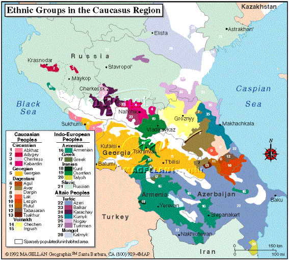 Contemporaneous with the later Maykop phase, the first Yamnaya complexes are present in the steppe zone shortly after 3300cal BC. The two Yamnaya individuals from the Rasshevatskiy 1 site establish a framework of dates for the Yamnaya in our study area, while somewhat younger dates have been reported from the Caspian steppe3. Yamnaya interments of the South Russian and North Caucasus plain share specific burial practices with other regional variants of this far-reaching supra-regional cultural network, they vary however by a more extensive use of burial goods. Complete or dismantled wooden wagons are frequently found in Yamnaya and related graves. Like those from the Volga region, the North Caucasian steppe complexes belong to the earliest representatives of the Yamnaya phenomenon in the Eurasian steppe. Stable isotope and palynological evidence argue for a mobile lifestyle based on pastoralism of these groups, but with rather limited mobility radii. The Velikent site at the coast of the Caspian Sea is a representative for a northern variant of the Kura-Araxes culture, albeit considerably different, which warrant its own Early Bronze Age designation (3300-2400/2200 calBCE). The site is over 30 ha in size and comprise of several settlement and cemetery mounds8, 21. Velikent and related sites are important for this study as they represent comprehensive agro-pastoral economies. 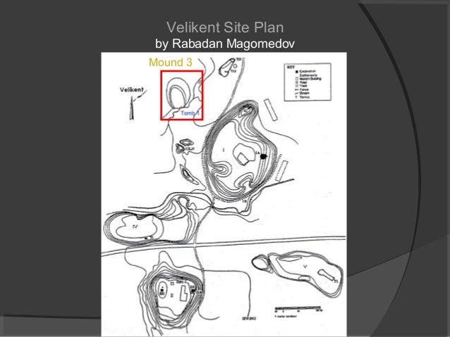 The Caucasian Middle Bronze Age is represented by the Catacomb grave formation (2800-2200 calBCE) mostly found in the steppe and by the North Caucasian cultural groups (2800-2400 calBCE) in the piedmont zone. Both represent economies that were based on mobile pastoralism. The first is one of several variants of the supra-regional Catacomb grave phenomenon, which split into even smaller region components in the North Caucasus and the Caspian steppe. With the Catacomb horizon the number of mounds and burials increases exponentially in the steppe. The North Caucasian formations in the piedmont and mountain zone likewise witness a fragmentation into smaller regional units with a rather heterogeneous artefact spectrum. However, the occupation of all ecological niches including the various steppe zones as well as the high mountains indicates, like in the Catacomb area, a considerable intensification of human activity. In particular, the mountain groups must have intensified mining as well, since burials now are frequently provided with metal artefacts, e.g. the complex of Lysogorskaya 6 in this study. After 2400 calBCE, Catacomb complexes first overlap with those of the North Caucasian groups and then seem to replace them. The climatic deterioration of the 4.2ky event led to a dissolution of both the Catacomb and the North Caucasian cultural formations, replacing them in the steppe and piedmont steppe by cultures of the post-Catacomb horizon or Late Bronze Age 1 (2200-1700 calBCE)11. The number of sites decrease rapidly. By 1700 calBCE the steppe including the zones directly at the foothills of the mountains are abandoned. Interments like those of Rasshevatskiy 4 and Nevinnomyskiy represent some of the late Bronze Age complexes. However, the mountain communities reorganized themselves in a final stage of North Caucasian traditions, as seen in complexes from Kabardinka or Kudachurt. These paved the way for a renewed intensification of a semi-mobile pastoral economy at high altitudes, which peaked as a highly efficient combined mountain agricultural system during the Late Bronze Age 2 (1700-1100/1000 calBCE)22. |
|


