|
|
Post by Admin on May 19, 2018 18:23:46 GMT
 Ecological background The mountain ranges of the Greater Caucasus and the southern Lesser Caucasus form a bridge linking the mountainous zones of the Near East to Eurasia. The South Caucasus river systems are connected to the upper Euphrates and Tigris drainage, and the mountain passes of the Great Caucasus offer a number of passages to the steppe landscapes north of it. However, the most important ecological demarcation is the interface of mountain and steppe ecozones in the North Caucasian foothills, a mid-altitude zone of hills and narrow plateaus and the slightly hilly piedmont steppe1. Intermediate biospheres, such as ecotopes, which are micro-environmental patches between larger vegetation zones, are characterized by higher biodiversity and provide fodder-rich landscapes ideal for pastoralism but also for basic agriculture2. This demarcation and the correlated ecotones fluctuated considerably during the Bronze Age. For instance, the 6 to 5 ky rapid climate change event placed Maykop sites in a much more steppe-like environment than it is today, while the 4.2 ky event put a halt to the exploitation of the steppe zone for several hundred years due to severe aridisation3. The ecological division separates mountain- and steppe-based economies despite the fact that both are biologically highly diverse environments with rich pastures ideal for mobile and semi-sedentary pastoralists and which are traditionally shared by groups practising such economies. At a local level, the Caucasus is therefore characterized by a large variety of specific economic and social adaptations. These are reflected in a large cultural and linguistic diversity, and complex networks of interaction within and between the Caucasus and the adjacent regions. Archaeological background The geographical dichotomy of the mountain and steppe-based economies in the Caucasus is also reflected in the high diversity of archaeological cultural phenomena4, 5, 6. Our study includes representatives of all major Bronze Age groups in the North Caucasus. They reflect affiliations to either mountain-associated cultural groups such as the Darkveti-Meshoko Eneolithic (4700-3500 calBCE)7, the Maykop phenomenon (3900-2900 calBCE)5, communities of a Northern variant of the Kura-Araxes culture (3600-2500 calBCE)8, the North Caucasian cultural formation or the mountain groups of the post-Catacomb grave horizon9, or to large-scale cultural phenomena of the steppe such as the Don-Kaspi Steppe Eneolithic (4300-4100 calBCE)10, the Yamnaya (3300-2600/2500 calBCE), the Catacomb cultural communities (2800-2200 calBCE)3 and the post-Catacomb Lola formation (2200-1700 calBCE)11. To represent the South Caucasus Kura-Araxes culture4 (3600-2500 calBCE), we also included individuals from the Kaps site in present-day Armenia. Each of these formations is outlined by particular sets of artefacts, settlement and burial practices, or adaptations to specific environments. However, the chronological overlap of sites within the same territory, regional variations in artefact spectra and a high frequency of elements crossing-over blur the delineation of clear cut ‘archaeological cultures’. Consequently, the applied terms must in their specific time frames be understood as operational tools rather than social entities that represent uniform and coherent peoples.  The significance of the Caucasus as a key study area is clearly visible in the current debate of large-scale cultural interaction in the 4th and 3rd millennium BCE in Western Eurasia. The impact of the archaeological cultures, which shaped this contact zone between the Near East and Eurasia during the Bronze Age, on the widening of social networks that operated between Mesopotamia, the Eurasian steppe and Europe is, however, still poorly understood12, 13. Early Neolithic communities establish a sedentary lifestyle with a Near Eastern set of domesticates in the South Caucasus by 6000 calBCE14. They developed a sophisticated set of settlements but kept to the floodplains of the major river drainages. Other Neolithic communities in the West Caucasian lowlands and at the Black Sea coast or in the central mountain valleys remain vague and might reflect local populations that selectively adopted elements of the Neolithic package. Neolithic elements in the Lower Don area north of the Caucasus and dating to the late 7th millennium BCE are disputed15 but might shed light on a southern component in the development of cultural formations before the actual advent of the Neolithic in the North Caucasus during the mid-5th millennium BCE. The earliest attested evidence of the Neolithic lifestyle in the North Caucasus, including domesticates and settlement architecture, dates to the mid-5th millennium BCE and is associated with a cultural formation termed Darkveti-Meshoko Eneolithic7 or ‘pearl-ornamented ceramic’. Sites associated with this phenomenon are situated on both flanks of the West Caucasian Mountains and in all probability reflect groups advancing through the mountain passes from the southern to the northern side of the mountains. This cultural phenomenon represents a rather dispersed and flimsy settlement of the mountain zones. Some habitation sites were found under rock shelters or in caves such as the site of Unakozovskaya, but large fortified settlements are present as well. The settlers lived on agriculture, cattle herding and pig-rearing. Complementary to the southern Eneolithic component, a northern component started to expand between 4300 and 4100 calBCE manifested in low burial mounds with inhumations densely packed in bright red ochre. Burial sites of this type, like the investigated sites of Progress and Vonyuchka, are found in the Don-Caspian steppe10, but they are related to a much larger supra-regional network linking elites of the steppe zone between the Balkans and the Caspian Sea16. These groups introduced the so-called kurgan, a specific type of burial monument, which soon spread across the entire steppe zone. |
|
|
|
Post by Admin on May 20, 2018 19:38:11 GMT
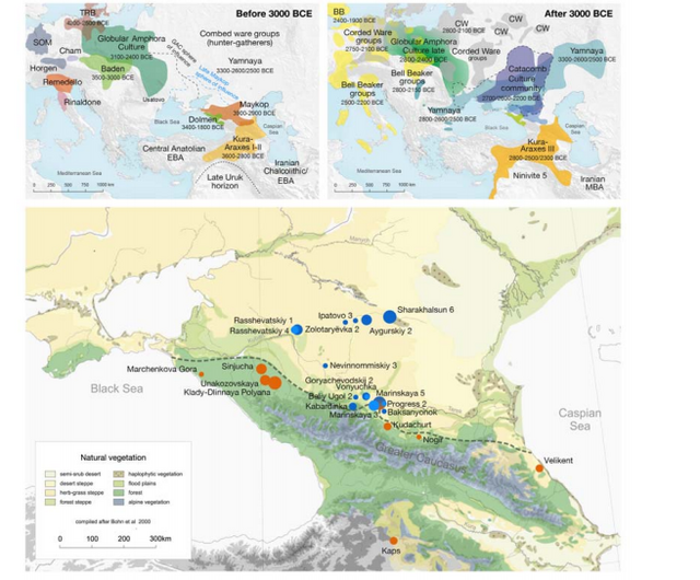 Fig. 1. Map of sites and archaeological cultures mentioned in this study. Admixture into the steppe zone from the south Evidence for interaction between the Caucasus and the Steppe clusters is visible in our genetic data from individuals associated with the later Steppe Maykop phase around 5300-5100 years ago. These ‘outlier’ individuals were buried in the same mounds as those with steppe and in particular Steppe Maykop ancestry profiles but share a higher proportion of Anatolian farmer-related ancestry visible in the ADMIXTURE plot and are also shifted towards the Caucasus cluster in PC space (Fig. 2D). This observation is confirmed by formal D-statistics (Steppe Maykop outlier, Steppe Maykop; X; Mbuti), which are significantly positive when X is a Neolithic or Bronze Age group from the Near East or Anatolia (Supplementary Fig. 4). By modelling Steppe Maykop outliers successfully as a two-way mixture of Steppe Maykop and representatives of the Caucasus cluster (Supplementary Table 3), we can show that these individuals received additional ‘Anatolian and Iranian Neolithic ancestry’, most likely from contemporaneous sources in the south. We estimated admixture time for the observed farmer-related ancestry individuals using the linkage disequilibrium (LD)-based admixture inference implemented in ALDER46, using Steppe Maykop outliers as the test population and Steppe Maykop as well as Kura-Araxes as references. The average admixture time for Steppe Maykop outliers is about 20 generations or 560 years ago, assuming a generation time of 28 years47 (Supplementary Information 6). Contribution of Anatolian farmer-related ancestry to Bronze Age steppe groups In principal component space Eneolithic individuals (Samara Eneolithic) form a cline running from EHG to CHG (Fig. 2D), which is continued by the newly reported Eneolithic steppe individuals. However, the trajectory of this cline changes in the subsequent centuries. Here we observe a cline from Eneolithic_steppe towards the Caucasus cluster. We can qualitatively explain this ‘tilting cline’ by developments south of the Caucasus, where Iranian and Anatolian/Levantine Neolithic ancestries continue to mix, resulting in a blend that is also observed in the Caucasus cluster, from where it could have spread onto the steppe. The first appearance of ‘Near Eastern farmer related ancestry’ in the steppe zone is evident in Steppe Maykop outliers. However, PCA results also suggest that Yamnaya and later groups of the West Eurasian steppe carry some farmer related ancestry as they are slightly shifted towards ‘European Neolithic groups’ in PC2 (Fig. 2D) compared to Eneolithic steppe. This is not the case for the preceding Eneolithic steppe individuals. The tilting cline is also confirmed by admixture f3-statistics, which provide statistically negative values for AG3 as one source and any Anatolian Neolithic related group as a second source peer-reviewed) is the author/funder. Detailed exploration via D-statistics in the form of D(EHG, steppe group; X, Mbuti) and D(Samara_Eneolithic, steppe group; X, Mbuti) show significantly negative D values for most of the steppe groups when X is a member of the Caucasus cluster or one of the Levant/Anatolia farmer-related groups (Supplementary Figs. 5 and 6). In addition, we used f- and D-statistics to explore the shared ancestry with Anatolian Neolithic as well as the reciprocal relationship between Anatolian- and Iranian farmer-related ancestry for all groups of our two main clusters and relevant adjacent regions (Supplementary Fig. 4). Here, we observe an increase in farmer-related ancestry (both Anatolian and Iranian) in our Steppe cluster,ranging from Eneolithic steppe to later groups. In Middle/Late Bronze Age groups especially to the north and east we observe a further increase of Anatolian farmer-related ancestry consistent with previous studies of the Poltavka, Andronovo, Srubnaya and Sintashta groups23, 27 and reflecting a different process not especially related to events in the Caucasus. 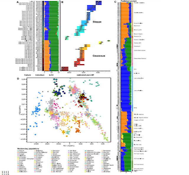 Fig. 2. ADMIXTURE and PCA results, and chronological order of ancient Caucasus individuals. (a) ADMIXTURE results (k=12) of the newly genotyped individuals (filled symbols with black outlines) sorted by genetic clusters (Steppe and Caucasus) and in chronological order (coloured bars indicate the relative archaeological dates, (b) white circles the mean calibrated radiocarbon date and the errors bars the 2-sigma range. (c) ADMIXTURE results of relevant prehistoric individuals mentioned in the text (filled symbols) and (d) shows these projected onto a PCA of 84 modern-day West Eurasian populations (open symbols). The exact geographic and temporal origin of this Anatolian farmer-related ancestry in the North Caucasus and later in the steppe is difficult to discern from our data. Not only do the Steppe groups vary in their respective affinity to each of the two, but also the Caucasus groups, which represent potential sources from a geographic and cultural point of view, are mixtures of them both23. We therefore used qpWave and qpAdm to explore the number of ancestry sources for the Anatolian farmer-related component to evaluate whether geographically proximate groups plausibly contributed to the subtle shift of Eneolithic ancestry in the steppe towards those of the Neolithic groups. Specifically, we tested whether any of the Eurasian steppe ancestry groups can be successfully modelled as a two-way admixture between Eneolithic steppe and a population X derived from Anatolian- or Iranian farmer-related ancestry, respectively. Surprisingly, we found that a minimum of four streams of ancestry is needed to explain all eleven steppe ancestry groups tested, including previously published ones (Fig. 2; Supplementary Table 12). Importantly, our results show a subtle contribution of both Anatolian farmer-related ancestry and WHG-related ancestry (Fig.4; Supplementary Tables 13 and 14), which was likely contributed through Middle and Late Neolithic farming groups from adjacent regions in the West. A direct source of Anatolian farmer-related ancestry can be ruled out (Supplementary Table 15). At present, due to the limits of our resolution, we cannot identify a single best source population. However, geographically proximal and contemporaneous groups such as Globular Amphora and Eneolithic groups from the Black Sea area (Ukraine and Bulgaria), which represent all four distal sources (CHG, EHG, WHG, and Anatolian_Neolithic) are among the best supported candidates (Fig. 4; Supplementary Tables 13,14 and 15). Applying the same method to the subsequent North Caucasian Steppe groups such as Catacomb, North Caucasus, and Late North Caucasus confirms this pattern (Supplementary Table 17). |
|
|
|
Post by Admin on May 21, 2018 18:36:59 GMT
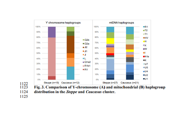 Using qpAdm with Globular Amphora as a proximate surrogate population (assuming that a related group was the source of the Anatolian farmer-related ancestry), we estimated the contribution of Anatolian farmer-related ancestry into Yamnaya and other steppe groups. We find that Yamnaya individuals from the Volga region (Yamnaya Samara) have 13.2±2.7% and Yamnaya individuals in Hungary 17.1±4.1% Anatolian farmer-related ancestry (Fig.4; Supplementary Table 18)– statistically indistinguishable proportions. Replacing Globular Amphora by Iberia Chalcolithic, for instance, does not alter the results profoundly (Supplementary Table 19). This suggests that the source population was a mixture of Anatolian farmer-related ancestry and a minimum of 20% WHG ancestry, a profile that is shared by many Middle/Late Neolithic and Chalcolithic individuals from Europe of the 3rd 448 millennium BCE analysed thus far. To account for potentially un-modelled ancestry from the Caucasus groups, we added ‘Eneolithic Caucasus’ as an additional source to build a three-way model. We found that Yamnaya Caucasus, Yamnaya Ukraine Ozera, North Caucasus and Late North Caucasus had likely received additional ancestry (6% to 40%) from nearby Caucasus groups (Supplementary Table 20). This suggests a more complex and dynamic picture 455 of steppe ancestry groups through time, including the formation of a local variant of steppe ancestry in the North Caucasian steppe from the local Eneolithic, a contribution of Steppe Maykop groups, and population continuity between the early Yamnaya period and the Middle Bronze Age (5300-3200 BP, 3300-2200 calBCE). This was interspersed by additional, albeit subtle gene-flow from the West and occasional equally subtle gene flow from neighbouring groups in the Caucasus and piedmont zones. 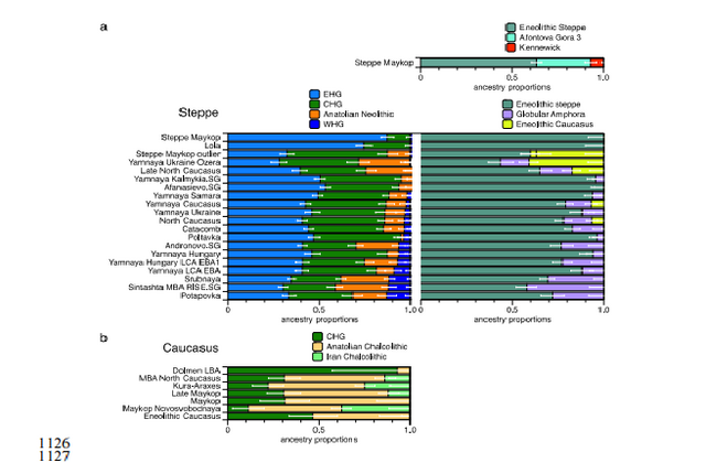 Fig. 4. Modelling results for the Steppe and Caucasus cluster Our results show that at the time of the eponymous grave mound of Maykop, the North Caucasus piedmont region was genetically connected to the south. Even without direct ancient DNA data from northern Mesopotamia, the new genetic evidence suggests an increased assimilation of Chalcolithic individuals from Iran, Anatolia and Armenia and those of the Eneolithic Caucasus during 6000-4000 calBCE23, and thus likely also intensified cultural connections. Within this sphere of interaction, it is possible that cultural influences and continuous subtle gene flow fromthe south formed the basis of Maykop (Fig. 4; Supplementary Table 10). In fact, the Maykop phenomenon was long understood as the terminus of the expansion of South Mesopotamian civilisations in the 4th millennium BCE11, 12, 51. It has been further suggested that along with the cultural and demographic influence the key technological innovations that had revolutionised the late 4th millennium BCE in western Asia had ultimately also spread to Europe52. An earlier connection in the late 5th millennium BCE, however, allows speculations about an alternative archaeological scenario: was the cultural exchange mutual and did e.g. metal rich areas such as the Caucasus contribute substantially to the development and transfer of these innovations53, 54 ? |
|
|
|
Post by Admin on May 22, 2018 18:35:02 GMT
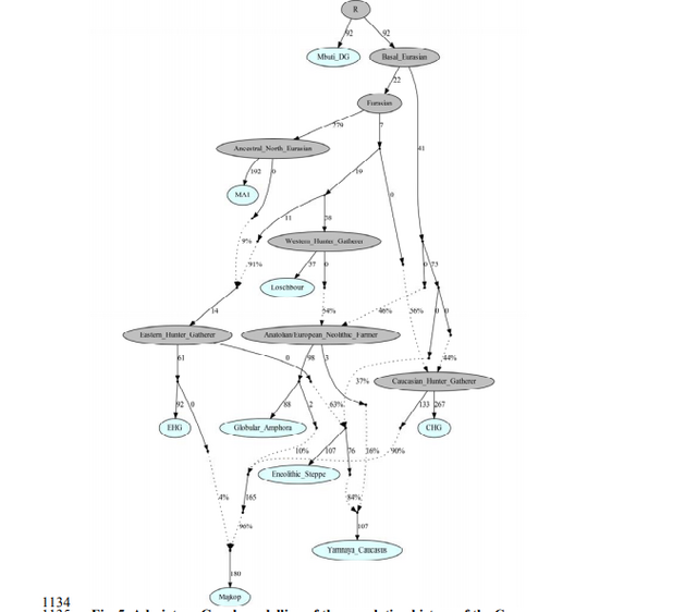 Fig. 5. Admixture Graph modelling of the population history of the Caucasus region. When compared to present-day human populations from the Caucasus, which show a clear separation into North and South Caucasus groups along the Great Caucasus mountain range (Fig. 2D), our new data highlights that the situation during the Bronze Age was quite different. The fact that individuals buried in kurgans in the North Caucasian piedmont and foothill zone are more closely related to ancient individuals from regions further south in today’s Armenia, Georgia and Iran allows us to draw two major conclusions. First, sometime after the Bronze Age present-day North Caucasian populations must have received additional gene-flow from populations north of the mountain range that separates them from southern Caucasians, who largely retained the Bronze Age ancestry profile. The archaeological and historic records suggest numerous incursions during the subsequent Iron Age and Medieval times48, but ancient DNA from these time periods is needed to test this directly. Second, our results reveal that the Greater Caucasus Mountains were not an insurmountable barrier to human movement in prehistory. Instead the foothills to the north at the interface of the steppe and mountain ecozones could be seen as a transfer zone of cultural innovations from the south and the adjacent Eurasian steppes to the north, as attested by the archaeological record. The latter is best exemplified by the two Steppe Maykop outlier individuals dating to 5100-5000 yBP/3100-3000 calBCE, which carry additional Anatolian farmer-related ancestry likely derived from a proximate source related to the Caucasus cluster. We could show that individuals from the contemporaneous Maykop period in the piedmont region are likely candidates for the source of this ancestry and might explain the regular presence of ‘Maykop artefacts’ in burials that share Steppe Eneolithic traditions and are genetically assigned to the Steppe group. Hence the diverse ‘Steppe Maykop’ group indeed represents the mutual entanglement of Steppe and Caucasus groups and their cultural affiliations in this interaction sphere.  Concerning the influences from the south, our oldest dates from the immediate Maykop predecessors Darkveti-Meshoko (Eneolithic Caucasus) indicate that the Caucasus genetic profile was present north of the range ~6500 BP, 4500 calBCE. This is in accordance with the Neolithization of the Caucasus, which had started in the flood plains of the great rivers in the South Caucasus in the 6th millennium BCE from where it spread to the West and Northwest Caucasus during the 5th millennium BCE9, 49. It remains unclear whether the local CHG ancestry profile (represented by Late Upper Palaeolithic/Mesolithic individuals from Kotias Klde and Satsurblia in today’s Georgia) was also present in the North Caucasus region before the Neolithic. However, if we take the Caucasus hunter-gatherer individuals from Georgia as a local baseline and the oldest Eneolithic Caucasus individuals from our transect as a proxy for the local Late Neolithic ancestry, we notice a substantial increase in Anatolian farmer-related ancestry. This in all likelihood is linked to the process of Neolithization, which also brought this type of ancestry to Europe. As a consequence, it is possible that Neolithic groups could have reached the northern flanks of the Caucasus earlier50 (Supplementary Information 1) and in contact with local hunter gatherers facilitated the exploration of the steppe environment for pastoralist economies. Hence, additional sampling from older individuals is needed to fill this temporal and spatial gap. The insight that the Caucasus mountains served not only as a corridor for the spread of CHG/Neolithic Iranian ancestry but also for later gene-flow from the south also has a bearing on the postulated homelands of Proto-Indo-European (PIE) languages and documented gene-flows that could have carried a consecutive spread of both across West Eurasia17, 64. Perceiving the Caucasus as an occasional bridge rather than a strict border during the Eneolithic and Bronze Age opens up the possibility of a homeland of PIE south of the Caucasus, which itself provides a parsimonious explanation for an early branching off of Anatolian languages. Geographically this would also work for Armenian and Greek, for which genetic data also supports an eastern influence from Anatolia or the southern Caucasus. A potential offshoot of the Indo-Iranian branch to the east is possible, but the latest ancient DNA results from South Asia also lend weight to an LMBA spread via the steppe belt21. The spread of some or all of the proto-Indo-European branches would have been possible via the North Caucasus and Pontic region and from there, along with pastoralist expansions, to the heart of Europe. This scenario finds support from the well attested and now widely documented ‘steppe ancestry’ in European populations, the postulate of increasingly patrilinear societies in the wake of these expansions (exemplified by R1a/R1b), as attested in the latest study on the Bell Beaker phenomenon35. |
|
|
|
Post by Admin on May 24, 2018 18:30:54 GMT
 Marinskaya 5, Russia N43.905354°, E 43.521883° Excavation Lomonosov Moscow State University, Institute of Archaeology RAS, ‘Nasledie’ 2009, licence № 2009745 (A.R. Kantorovich), 2009-762 (V.Ye. Maslov) The huge, single-standing burial mound Marinskaya 5, situated 2.3 km southwest of the mound group Marinskaya 3 was excavated in 2009 by a team of the Lomonosov Moscow State University, the Institute of Archaeology RAS and the local heritage organization ‘Nasledie’. The kurgan is situated on the high terrace of the river Kura. The mound was slightly oval with a diameter of 34 to 40 m and 4.3 m high. At a distance of 10-16 m a ditch of 1.5 m depth surrounded the mound, which was detected on aerial images and excavated later. In the central part of the mound, the excavations uncovered three mound-shells or construction phases dating to the Early Bronze Age Maykop epoch and one that was constructed during the Middle Bronze Age. The first constructive feature in the mound was the above-ground burial vault of grave 33, surrounded by an oval fencing built from river pebbles. The first shell, an earth and stone construction, was built directly on top of this construction. Two following early Maykop burials 32 and 34 were entrenched in the centre. The second mound-shell was associated with late Maykop burials 12 and 16 and was added later. The third mound-shell was constructed after the interment of late Maykop grave 25. These mound-shells were complex earthen constructions and each were covered by a stone shell. All burials except grave 25 were situated on top of each other in the centre of the mound. Grave 12 is dendrochronologically dated27, all others inhumations are radiocarbon dated. The Maykop stratigraphy has recently been published in Russian34. In several graves, among them late Maykop grave 25 and North Caucasus graves 19, 23, 30/30a, paired cattle skulls were found. They place this site among one of the earliest, where the use of cattle as draught animals is documented in a chronological sequence6. After a hiatus of 600 years 18 graves (no. 3, 10, 13, 15, 17-24, 26-29, 30A, and 31) dating to the North Caucasus cultural formation were added, including another mound shell. Two graves (no. 4 and 14) dated to the Late Bronze Age/post-Catacomb epoch based on burial practice and radiocarbon dates, and two nearly destroyed burials (no. 8 and 11) perhaps also date to the Bronze Age. One catacomb grave, also dating to the local Middle Bronze Age, intersected the ring of the North Caucasus graves and destroyed an earlier interment (no. 30/30A). During the Late Iron Age five additional graves were added in the centre of the mound. which can be attributed to the Sarmatian epoch. Grave 1 can be associated with the Early Iron Age of the late 8th to early 7th century BCE and the others (no. 2, 5, 6, 9) date to the early Sarmatian epoch, i.e. the 3rd to 1st century BCE. •MK5005.C0101.TF1 (BZNK-079/1), kurgan 1, grave 32, an early Maykop secondary interment into the second mound-shell on top of the first burial. The grave was without inventory but is according to the stratigraphy associated with the early Maykop complexes. Dating: leather 3640-3370 calBCE (4720±25BP, UGAMS-13047); human bone 3341-3098 calBCE (4496±26BP, MAMS-11212) •MK5001.A0101.TF1+ B0101.TF1 (BZNK-065/5+3), kurgan 1, grave 12, a partly disturbed Late Maykop inhumation slightly south of the centre with bronze weapons and a ceramic vessel. The grave is dendrochronologically dated with an end date of 3279 BCE + 25 years for missing sapwood27. Dating of the skeleton: 3348-3035 calBCE (4491±32BP, MAMS-110555) •MK5008.B0101.TF1 (BZNK-066/3), kurgan 1, grave 16, a Late Maykop inhumation in the center of the mound with a wooden vessel(?). Dating: 3364-3107 calBCE (4544±25BP, MAMS-29810) •MK5004.A0101.TF1+D0101 (BZNK-073/4+2), kurgan 1, grave 25, which was a disturbed Late Maykop inhumation burial in a square burial chamber. Bronze weapons, a golden earring and a ceramic vessel remained from the inventory. Additionally, two cattle skulls with bronze nose rings and the remains of a possible yoke were found in situ outside the chamber. Dating of wood remains from the grave construction: 3347-3095 calBCE (4498±30BP, MAMS-110554) •MK5009.A0101.TF1 (BZNK-064/2), kurgan 1, grave 10, a North Caucasus grave inside a well preserved wooden massive construction in a deep grave shaft. The inventory included a stone object and animal bones. This complex is likewise dendrochronologically dated with an end date of 2644 BCE + 13 years uncertainty for missing sapwood27. Dating of the skeleton: 2884-2636 calBCE (4175±31BP, MAMS-110548)  Aygurskiy 2, Russia N 45.690°, E 43.262° Excavation ‘Nasledie’ 2000, Stavropol, licence №2000-776 (V. A. Babenko) The Aygurskiy burial mound cemetery 2 was situated on a promontory overlooking the small river of Aygurki, about 22 km east of the city of Ipatovo. The area is a slightly hilly landscape, today in a desert steppe environment1. However, like the vicinity of the Ipatovo mound, vegetation zones might have shifted here with changing climate conditions. The valley belongs to the river Kalaus drainage system. All 37 burial mounds of the cemetery, of which mound 22 was the largest and placed slightly aside the others, were excavated by the local heritage organization ‘Nasledie’ in 1998-2001. The mound itself was slightly oval, had a diameter of 38 m and a maximal height of 1.8 m. It comprised three major mound construction phases of which the first was a complex stone construction dating to the Maykop epoch23. The sampled individuals stem from this first mound phase. The first interments in the mound, grave 8 and 8a were found in a massive stone box covered by a cairn-like stone package. It was surrounded by a large circle of vertical stone slabs, some collapsed to the interior. Graves 9, 15 and 16 were added inside the circle, some covered by collapsed stones of the stone circle. The entire constructing was then filled with a layer of topsoil. It was covered by a stone shell and an earthen mound-shell 1. The remaining 12 graves date chiefly to the Middle and Late Bronze Age and are associated with the North Caucasian cultural formation (graves 4, 10), the Catacomb cultural formation (graves 7, 12-12) and a late or post-Catacomb horizon (graves 1, 3, 11, 12). Graves 2, 5 and 6 are uncertain in date. The Maykop individuals were part of a paleoanthropological study24 and investigated with regards to their radiocarbon and stable isotope composition25. Paired radiocarbon dates on human and animal bones, chiefly herbivores, revealed radiocarbon off-sets for some bones (see comments below), but confirm a mid to late Maykop date for all graves. The particularities of inventories and grave construction together with the location of the site in the grass-steppe zone associate these complexes with our Steppe-Maykop cultural formation. Two sampled individuals from this Maykop complexes produced genome-wide data. •AY2003.A0101.TF1 (BZNK-289/1), kurgan 22, grave 9, was the burial of a 1.5-year-old child in an oval burial pit covered by stones and associated with two ceramic vessels, a flint flake and an astragalus23. Dating: human bone 3634-3377 calBCE (4726±31 BP, OxA-16147), animal bone 3638-3531 calBCE (4798±33 BP, OxA-16201), showing no radiocarbon offset in diet25. •AY2001.A0101.TF1 (BZNK-290/1), kurgan 22, grave 15 of an 55-65-year-old female in a long-oval pit with entrance shaft, partly covered by stones and associated with a ceramic vessel. Dating: human bone 3359-3013 calBCE (4480±50 BP, GIN-11811), 3630-3372 calBCE (4698±32 BP, OxA-16182), animal bone 3619-3378 cal BCE (4608±31 BP, OxA-16183), indicating a reservoir offset of -157 to -97 years. We would suggest that the age of the human is more likely to date to the period indicated by the animal bone dated25. |
|


